Dr. J. Staab Research
Your Navigator for GeoAI in Urban Environments
Leverage Geospatial Data for AI-Informed Decisions
 Multimodal Data
 Innovative Methods
 Actionable Insights
Today, we have the advanced capabilities to apply sophisticated AI models on multimodal, geospatial data. But how to foster innovative approaches, develop complex GIS processes and find cost-efficient solutions? I transfer academic research into planning practice, edge applications and local communities. Preferably with open-source tools and at low costs -- but I'm trained to sail the big ships, too. Either bring your own data, from UAVs, sensors and handheld cameras, or we leverage the vast amount of open satellite imagery and public geodata. With custom tools, we can extract required information supporting you to present data-driven decisions and manage complex urban processes tomorrow.
Expertise
Prompt Mapping in QGIS

Recent advances in generative AI are reshaping how spatial information can be accessed, interpreted, and communicated. By prompting in natural language enables a broader range of actors to engage with complex geospatial data and actively participate in design and analysis processes. This shift not only democratizes access to powerful analytical tools but also introduces a new level of usability—allowing rapid, cost-efficient generation of context-aware, photorealistic scenarios directly from existing datasets.
In practical terms, this makes the tool particularly valuable for early-stage innovation cycles. Ideas can be translated into tangible spatial representations within seconds, enabling fast iteration, comparison of alternatives, and more inclusive discussions before committing to resource-intensive planning and visualization workflows.
Computer Vision Applications
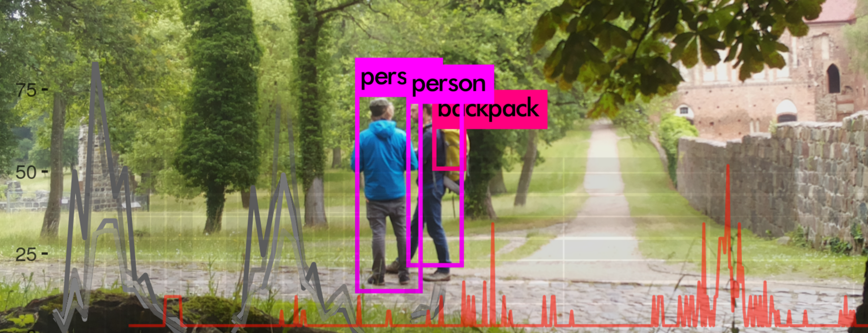
State-of-the-art libraries translate advanced earth observation techniques to diverse, real-world data streams. By applying established methodologies to webcam and drone imagery, highly detailed and dynamic insights can be extracted. This allows for comprehensive monitoring of elements such as traffic patterns, public space utilization, as well as environmental and infrastructural conditions.
These solutions are scalable and cost-effective. Using open-source software adapted to various hardware deliver robust monitoring capabilities and a high semantic level of detail in urban and suburban domains.
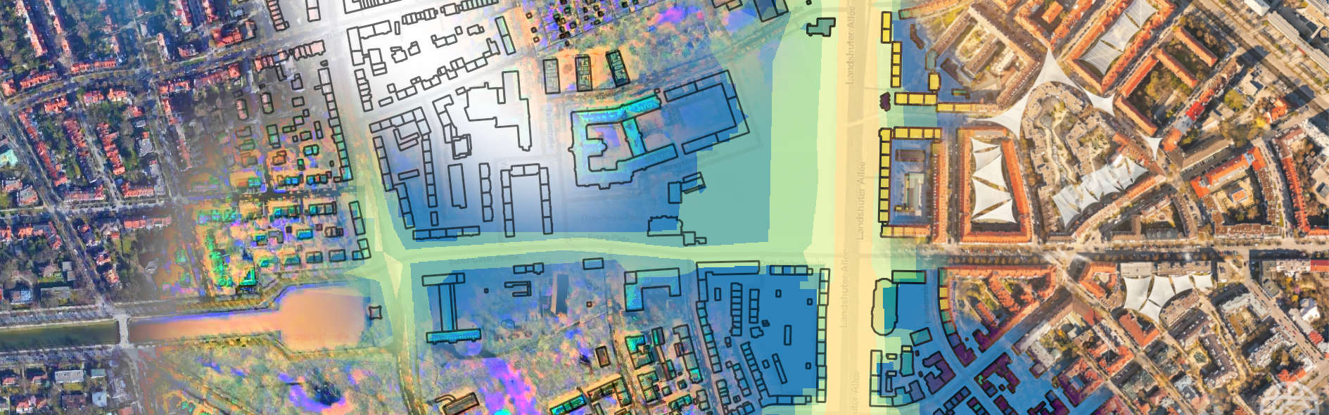
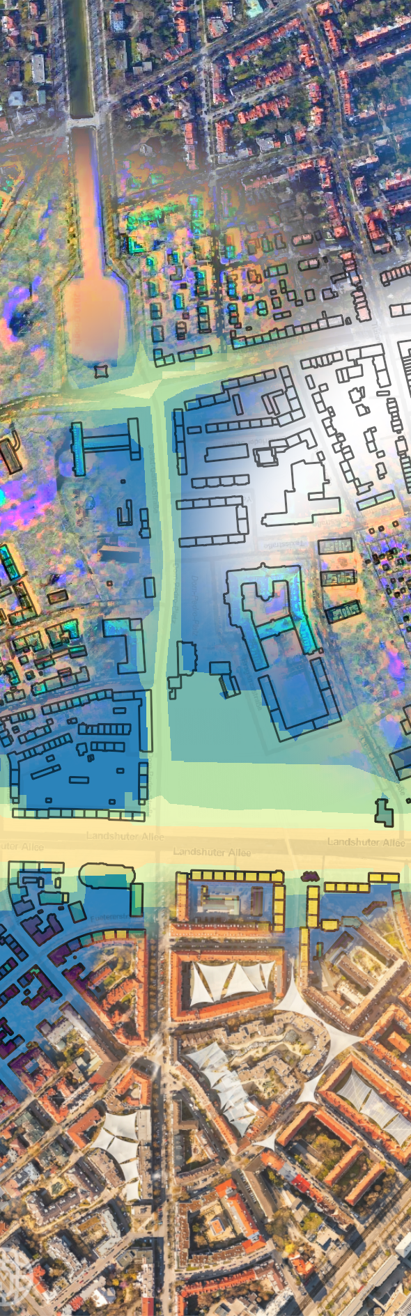
Urban Environmental Monitoring
Earth observation satellites continuously map the complexities of urban environments. In a very cost-efficient manner, advanced remote sensing technologies transform reflected sunlight into precise quantification of land use / land cover, public green spaces and other crucial surface characteristics.
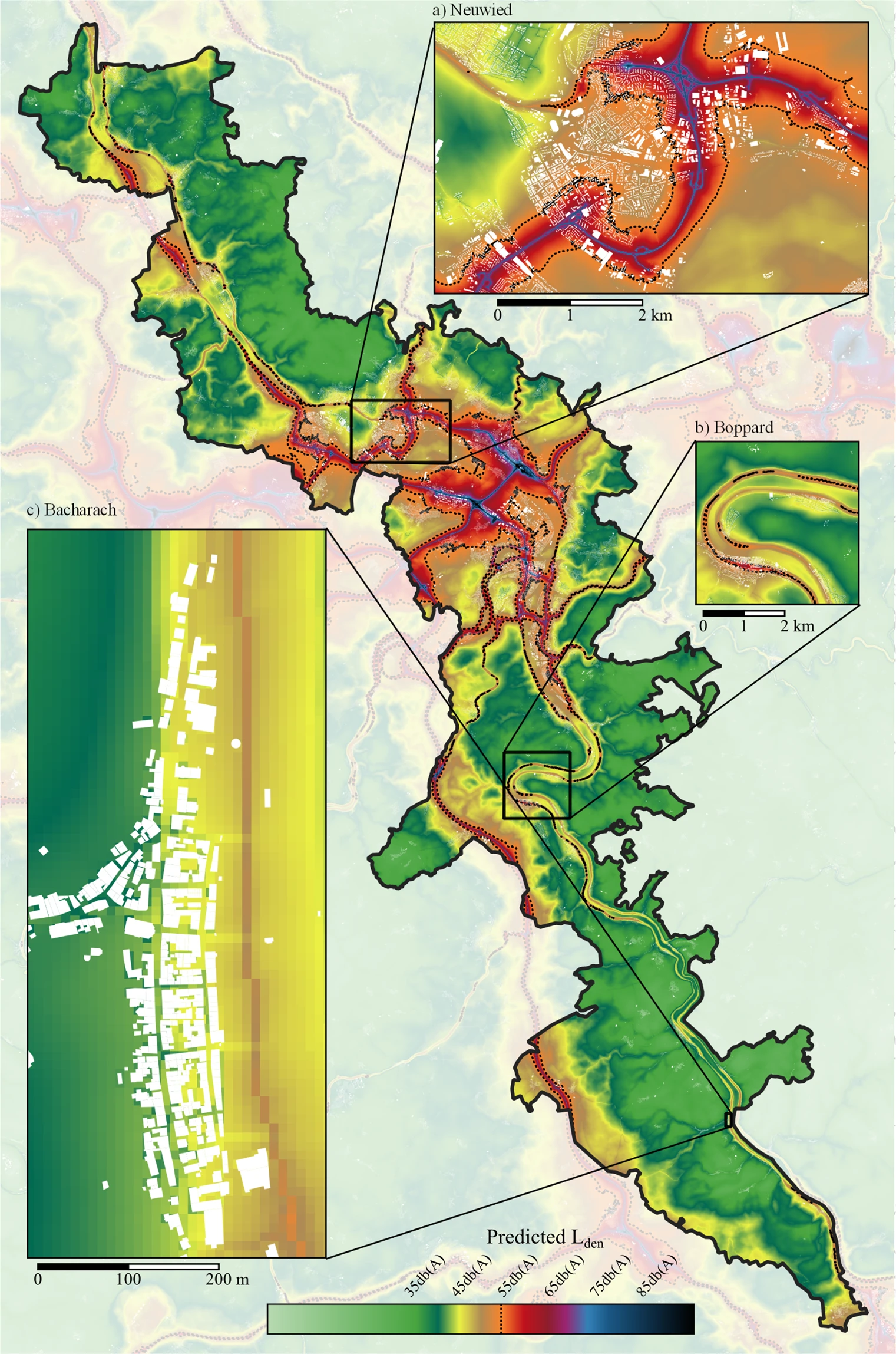
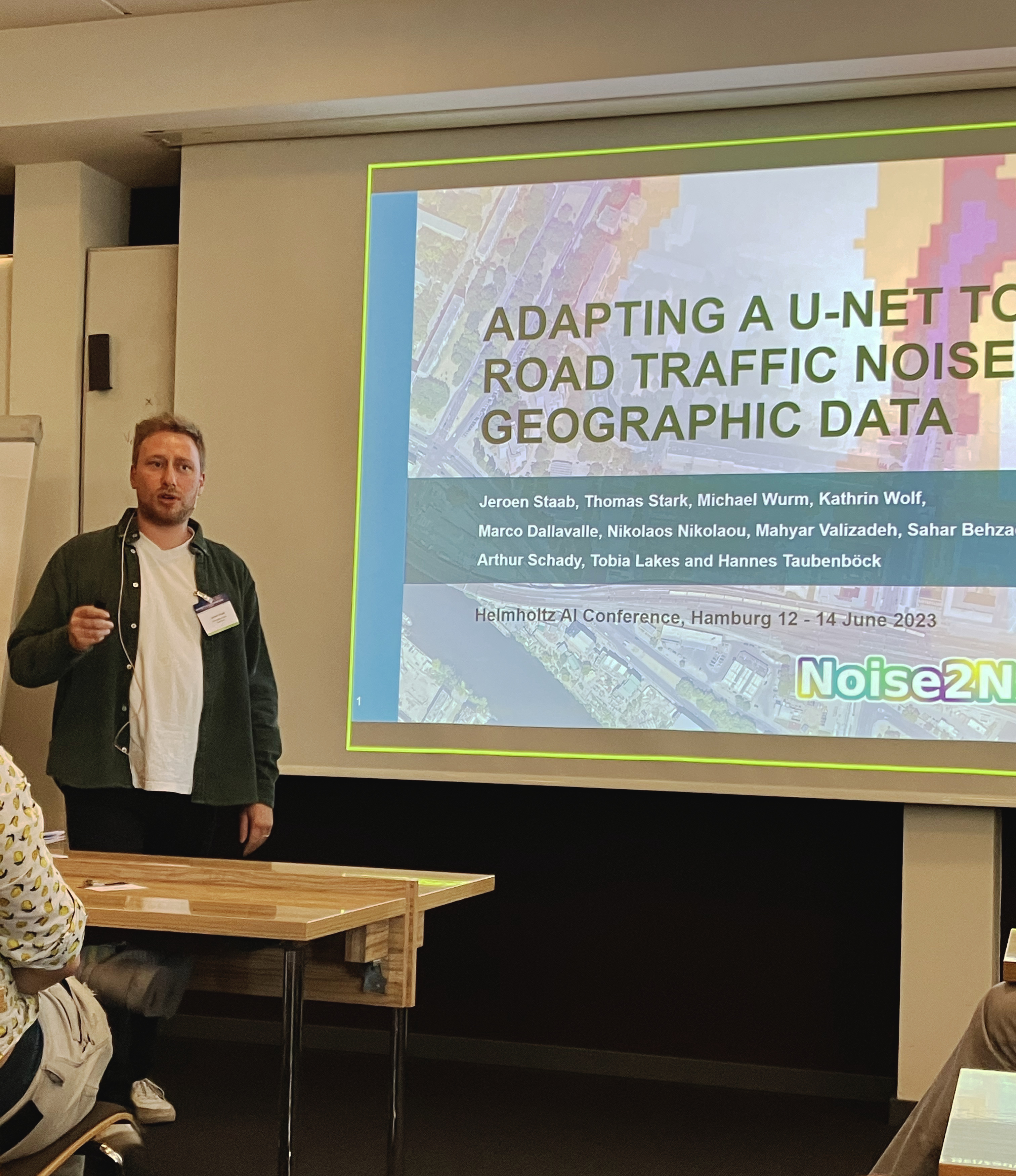
Furthermore, multimodal models allow for the abstraction of more intricate geoinformation, including detailed road traffic noise exposure data. Potentially on both, pan-European scale and multitemporal scope.
These comprehensive approaches, underpinned by robust geospatial data management, enable us to provide actionable insights for sustainable urban planning and environmental quality improvement.
Get Things Done
Developing a powerful solution is a straightforward process. Three steps efficiently lead to sustainable results. Let's start with a brief meeting to assess feasibility, timeline, and value for your enterprise.
01
Pilot Project
We launch a fast pilot to scientifically probe and fine-tune innovative methods specifically for your challenges.
02
Enterprise Rollout
The best configuration is rolled out as a scalable, enterprise-ready tool that delivers actionable insights and a clear competitive edge.
03
Comprehensive Onboarding
We finish with comprehensive onboarding, ensuring your team’s domain expertise is fully amplified.
About
Scientific Background
As a founder and scientist, Dr. rer. nat. Jeroen Staab dedicates himself to the intersection of Artificial Intelligence (AI), Geographic Information Systems (GIS), and urban environmental research.
His more than six years of experience at the German Aerospace Center (DLR) equipped him with extensive expertise in scientific project management and the analysis of complex spatial challenges. Complementing this practical foundation, his doctoral research at Humboldt-Universität zu Berlin further deepened his ability to provide data-driven solutions for administration and industry.
Contributed to more than fifteen peer-reviewed journal articles and being a speaker at international conferences, he strives to combine scientific depth and an interdisciplinary approach with practical applicability.
Projects
- Low Noise Behind the Structures - Lärmkartierung aus dem All (DBU)
- Noise2NAKOAI - AI Methods linking Environment and Health - a large-scale cohort application (Helmholtz AI)
- MetaMap3 - Metadata generation, enrichment and linkage across the three domains health, environment and earth observation (Helmholtz Metadata Collaboration)
- Digitaler Atlas 2.0 - Domänenübergreifende Softwareanwendungen und Geodateninfrastrukturen für die Prozessierung von Geodaten (DLR)
- OptiPlan - Ein innovatives KI-basiertes Planungstool zur Verkehrserfassung für nachhaltiges Flächenmanagement mittels Kamera- und Satellitenbilddaten (BMBF)
- HYBRID - Drohnendaten-Erfassung-KI-Opmiert (BMWK)
Online Me
Publications


Connections
Network
Successful projects and joint publications have build a solid foundation of trust, allowing me to operate with the support of a wide interdisciplinary expert network from research institutes and business partners.
Contact
Interested in advancing your projects with data-driven insights and scientific precision? Whenever you are ready for tailored solutions leveraging data and AI for you, don't hesitate to get in touch. Together we'll explore how advanced methods can generate lasting value for your specific challenges.